




























The day after the central Nepal flood

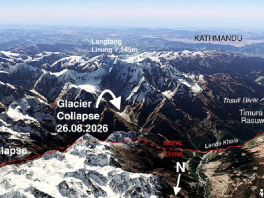
Satellite images show the glacial collapse on the North Face of Langtang was in Nepal itself
Originally published on Global Voices

Map by Google Earth via Nepali Times. Used with permission.
This story, written by Kunda Dixit, was originally published in Nepali Times. A slightly edited version is republished on Global Voices as part of a content-sharing agreement.
Mount Langtang Lirung, the majestic mountain that towers 7,245 meters above sea level and is located 45 kilometers directly north of Kathmandu, has a tragic history.
A massive 7.8 magnitude earthquake in April 2015 shook central Nepal and triggered an avalanche on its south face, which fell into the glacier below and buried the village of Langtang, killing at least 300 people.
On August 26th, there was a 4.4 magnitude earthquake near the border with China at exactly 8:37 a.m. Nepal Time (2:52 a.m. UTC). This time, it triggered a huge avalanche on the north face of Langtang.
While Langtang Lirung is wholly within Nepal, the debris flow from the avalanche blocked the monsoon-swollen Lhende Khola river that marks the border with China. The impounded lake burst soon after, sending a wall of mud, water, and boulders racing down the Trisuli River into Nepal.
At least that is what experts who have seen satellite images from Planet Labs have concluded. Scientists are still divided about whether the earthquake caused the slope collapse on the north face, or whether the avalanche was so massive that it caused the seismic event.
If the tremor was the trigger, it shook a mountain on which the snow and ice were already unstable due to global warming. Furthermore, it happened during the tail end of the monsoon season, when the slopes were heavy with snow, and the moraines left behind by glacial retreat that used to be bound tightly by permafrost were already saturated with water.
Even though this particular disaster seems to have originated on a glacier within Nepal, it exposes the increasing long-term threat of glacial lake outburst floods, permafrost melting, and moraine collapses causing transboundary disasters from the Tibetan Plateau.
Even without an earthquake trigger, there have been a series of recent Himalayan tsunamis caused by a combination of these same factors: Chamoli 2021, Melamchi 2021, Sikkim 2023, Thame 2024, Bhote Kosi 2025, and now 2026. Nearly all of these happened during the monsoon season.
Last year’s Rasuwagadhi flood on July 8th (detailed in the map below) killed 18 people, washed away the most important Nepal-China border checkpoint for trade and tourism, and destroyed highways, hydroelectric plants, and transmission lines in Nepal that were just being repaired from previous natural disasters.

Image by Google Earth via Nepali Times. Used with permission.
Scientists traced the flood's origin to enlarged supraglacial ponds that coalesced, burst, and sent a wall of debris downstream. Last year, the Chinese side was reported to have warned local authorities in Nepal of the danger. This year there was no warning at all.
Also, the avalanche and origin of the flood were much closer to the border; it would have been only a matter of minutes before the debris flow reached the Rasuwa checkpoint.
By August 27, 2026, the official death toll was climbing past 160, and is expected to number in the hundreds. Overnight, human bodies, animal carcasses and debris were seen floating down the Narayani River, 200 kilomsters downstream in Nawalparasi district.

Image via Nepali Times. Used with permission.
This disaster will bring up the issue of the Loss and Damage fund that Nepal has been raising in international climate negotiations regarding the economic impact of the climate crisis, especially in vulnerable mountain countries. The loss to infrastructure and property will be in the billions of dollars.
In a matter of minutes, at least six major hydropower plants, transmission lines, and electric substations on the Bhote Kosi and Trisuli were either destroyed or heavily damaged. Nepal’s showcase 25 megawatt grid-scale solar generation plant in Nuwakot was buried in sediment.
Other under-construction projects also suffered catastrophic damage. At least a dozen bridges across the Bhote Kosi and Trisuli, some of them 70 kilometers downstream, have been swept away, cutting off highways leading north.

Image via Nepali Times. Used with permission.
The disaster has hit Nepal almost exactly a year after the GenZ protests in September 2025 forced early elections, which Prime Minister Balendra Shah’s Rastriya Swatantra Party (RSP) swept in a landslide victory. His government has been in power less than six months, and now faces the challenge of immediate search and rescue and widespread rehabilitation along the ravaged Trisuli Valley.
In the longer term, Nepal will need to have an effective strategy to deal with seismic and climate change-induced disasters that are almost certainly going to increase in the future.
What's Your Reaction?
 Like
0
Like
0
 Dislike
0
Dislike
0
 Love
0
Love
0
 Funny
0
Funny
0
 Angry
0
Angry
0
 Sad
0
Sad
0
 Wow
0
Wow
0